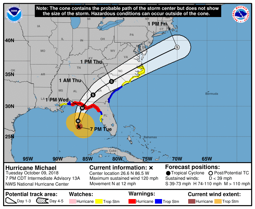
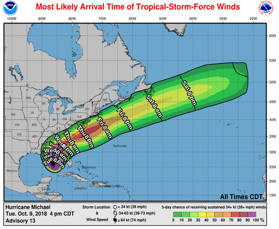
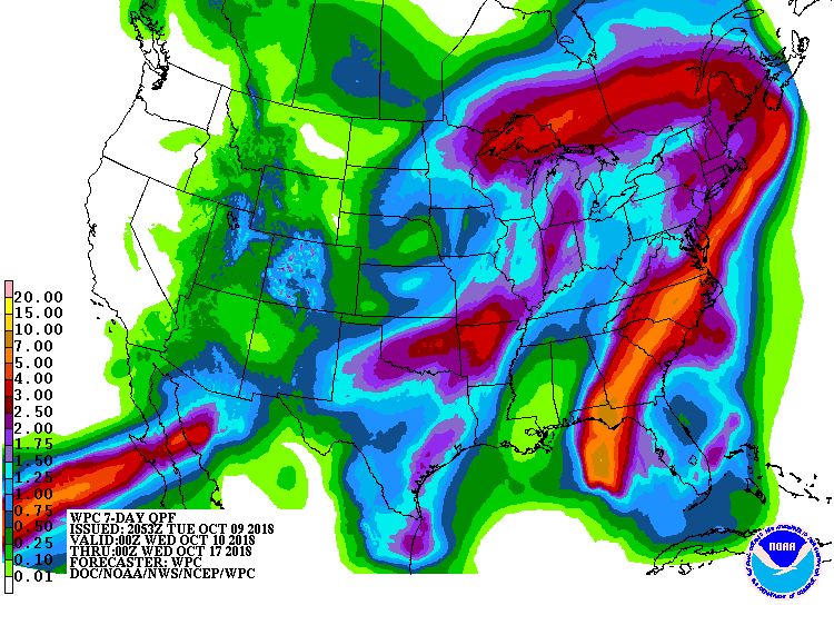
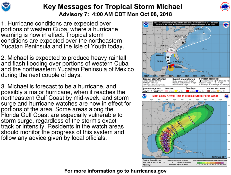
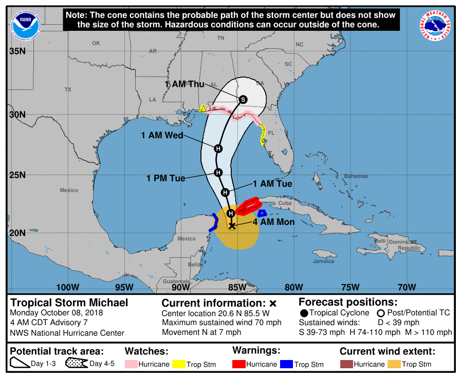
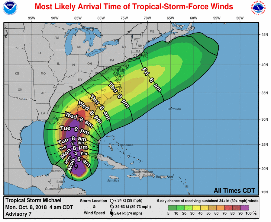
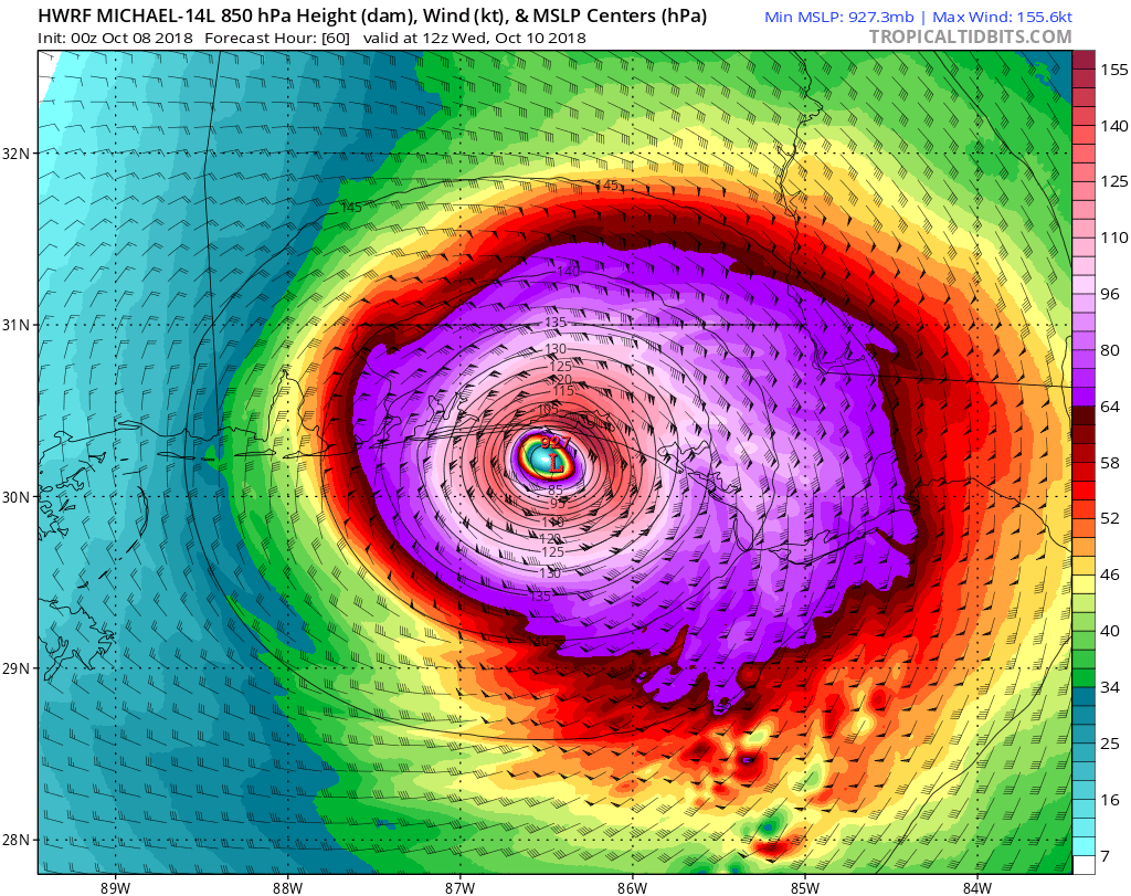
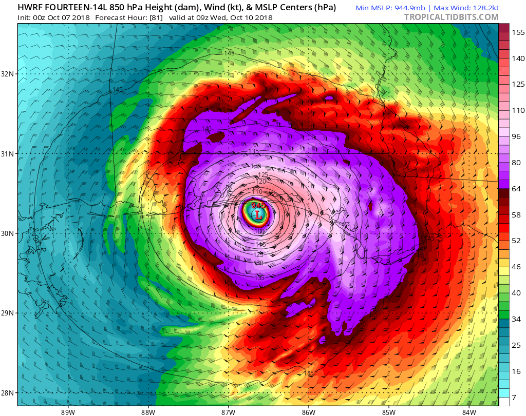
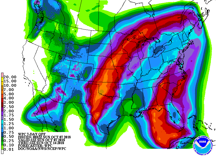
Major Hurricane Michael will make landfall around 1 PM Wednesday
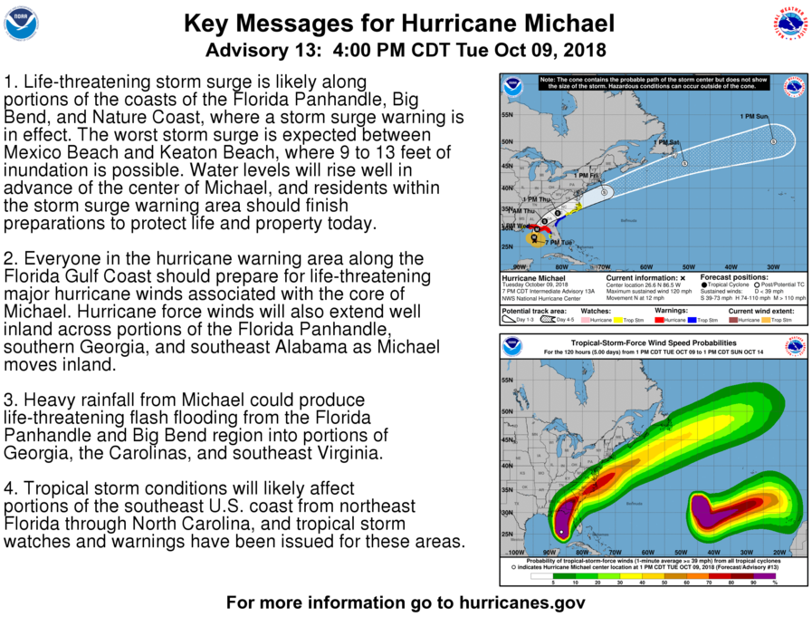
9:00 PM EDT 10/09/2018
Michael has strengthened to a category 3 hurricane. The storm continues on a North-Northwest movement. Now is the time to get preparations rushed to completion. Winds of 125 to 130 is possible at landfall, Between Destin and Apalachicola Florida. Storm surge of 10-18 feet is possible in the florida big-bend.
Top: Track
Middle: Arrival time of winds
Bottom: QPF
Comments
0 comments
Michael is hours from being a hurricane; watches issued as Michael will bring hurricane conditions to Florida Wednesday
6:30 AM EDT 10/08/2018
14 became Michael yesterday afternoon. Now it has rapidly intensified, and has winds of 70 MPH. It will likely become a hurricane in the next few hours. Hurricane watches are in effect for all of the Florida panhandle from the AL/FL border to the Suwanee river. Winds of 110 to 120 are possible at landfall. T.S. winds will arrive Wednesday morning for most of the FL coast.
Top: 3 day cone
Bottom: A.T.O.W Most likely
Impacts
As the storm is closing in, the impacts are becoming more obvious. There will be hurricane force winds of 75 to 115 MPH in the Hurricane watch area, and 40 to 70 MPH in the Tropical storm watch area. There will be a possibility for significant to extreme storm surge in areas. Tornadoes and heavy rain are not out of the question. Stay tuned to the NHC, and this website for more information on this developing situation.
Top: HWRF Model
Bottom: QPF
Top: HWRF Model
Bottom: QPF
Comments
0 Comments
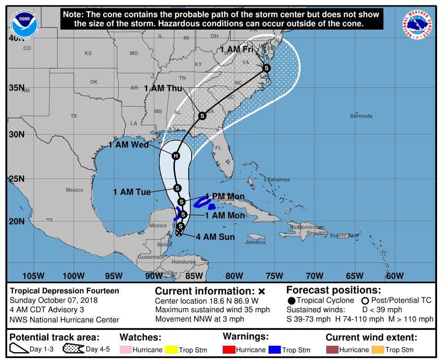
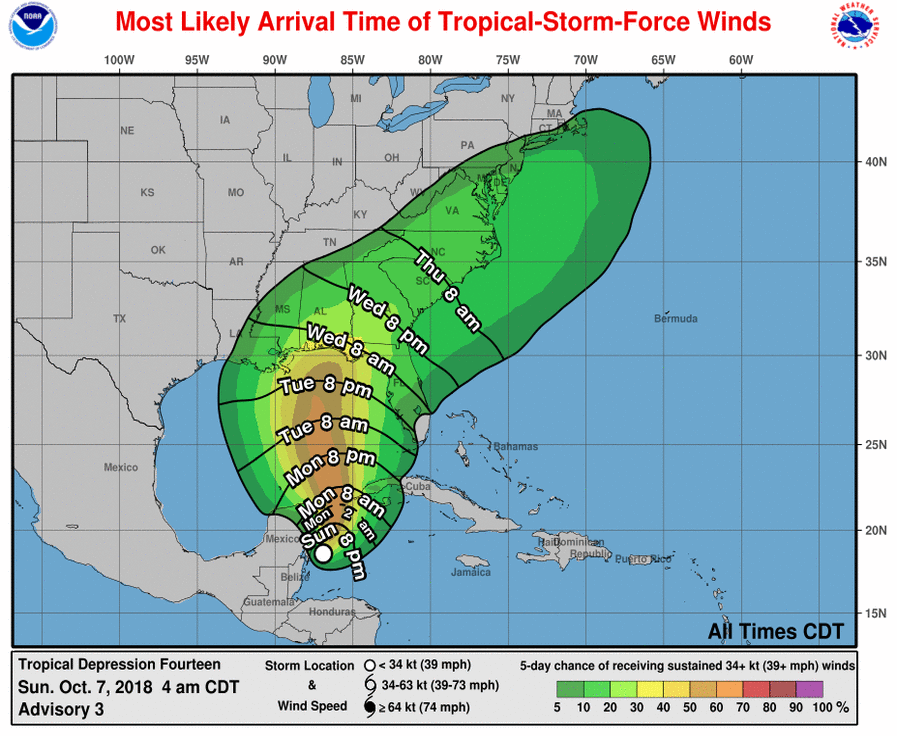
Fourteen Forms; Hurricane conditions expected Wednesday afternoon in US
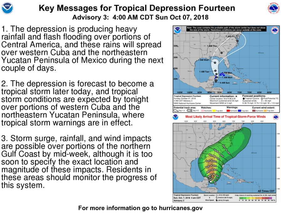
6:00 AM EDT 10/07/2018
PTC Fourteen has become TD fourteen. The NHC stated that the circulation is well-organized, therefore it's a tropical cyclone. It will bring tropical storm conditions to the Yucatan peninsula today.
Top: 5 Day cone
Bottom: Arrival time of winds (Most likely)
PTC Fourteen has become TD fourteen. The NHC stated that the circulation is well-organized, therefore it's a tropical cyclone. It will bring tropical storm conditions to the Yucatan peninsula today.
Top: 5 Day cone
Bottom: Arrival time of winds (Most likely)
Impacts
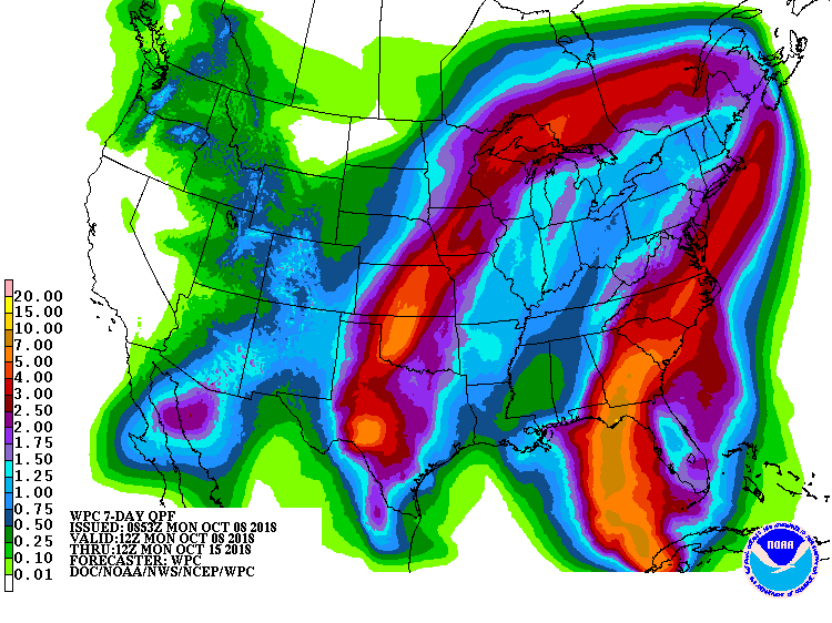
There is still some uncertainty about US Impacts. There is a Tropical Storm Warning For parts of Mexico and Cuba. At the US, heavy rain totals of 3 to 6 inches are likely. Tropical storm conditions will likely arrive around Wednesday 8 AM for Most of Florida and Alabama. The worst of the weather will be around landfall. It is too early to know where it will make landfall. The NHC has it around Panama City. Many models have it between Pensacola and Destin. Anyone with wind probabilities should watch this system very closely, and have there Hurricane plan ready.
Top: HWRF Model
Bottom: QPF
Top: HWRF Model
Bottom: QPF
Comments
0 Comments
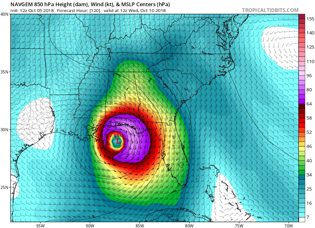
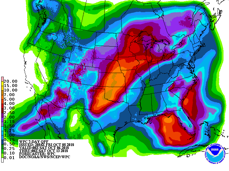
Disturbance could bring Tropical storm or hurricane conditions to Gulf Coast
5:00 PM EDT 10/05/2018
A cyclonic gyre is producing a large area of cloudiness and thunderstorms across the Western Caribbean Sea. This system will develop into a tropical depression late this weekend or early next week. The track will likely be into Alabama or Florida. This will be a similar intensity to Gordon. It has a 70% chance of becoming a tropical cyclone.
Top: 2 Day
Bottom: 5 Days

Impacts
It is too early to discus impacts confidently. What will happen is wind and rain. Rip currents will also occur. This is something to watch closely.
Top: NAVGEM Model
Bottom: QPF
Top: NAVGEM Model
Bottom: QPF
Comments
0 comments
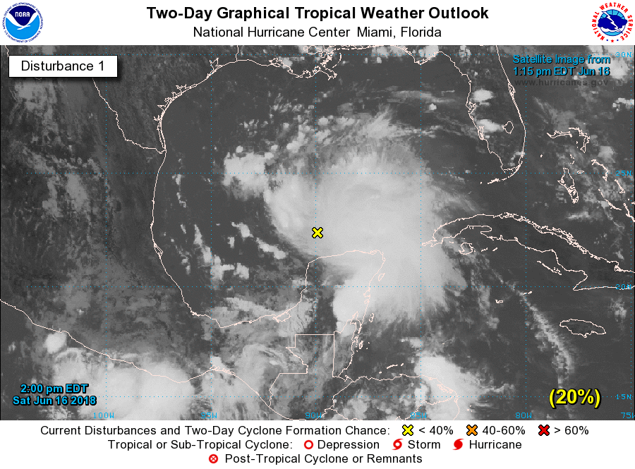
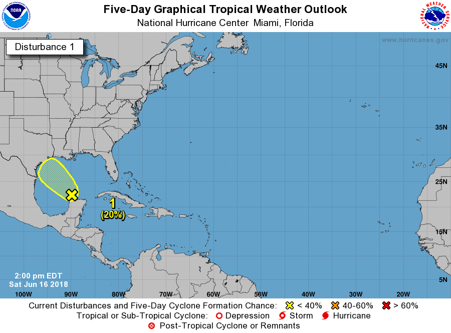
New disturbance poses flooding threats for Texas, Louisiana
3:00 PM EDT 06/16/2018
A new disturbance is located north of the Yucatan peninsula. This system will move toward Houston, Texas. This system has increased in coverage, but this will not likely develop. Forecasters have given this system a 20% chance of development over 2 days and 5 days.
Top: 2 day
Bottom: 5 day
A new disturbance is located north of the Yucatan peninsula. This system will move toward Houston, Texas. This system has increased in coverage, but this will not likely develop. Forecasters have given this system a 20% chance of development over 2 days and 5 days.
Top: 2 day
Bottom: 5 day
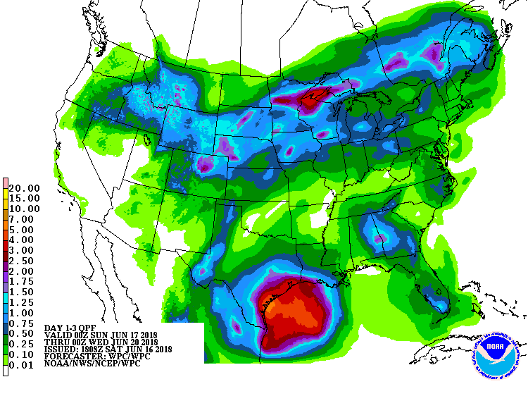
Impacts
There will be some heavy rain. 3 to 7 inches of rain will be possible over coastal Texas, and 1 to 4 inches over inland Texas, and a Flood or Flash Flood Watch may become required. High rip currents will be expected, as well as some dangerous surf. Gusty winds will be possible. This system will not likely develop, and if it does, it will only be a Tropical depression over coastal Texas.
Image: QPF
Image: QPF
Comments
0 comments
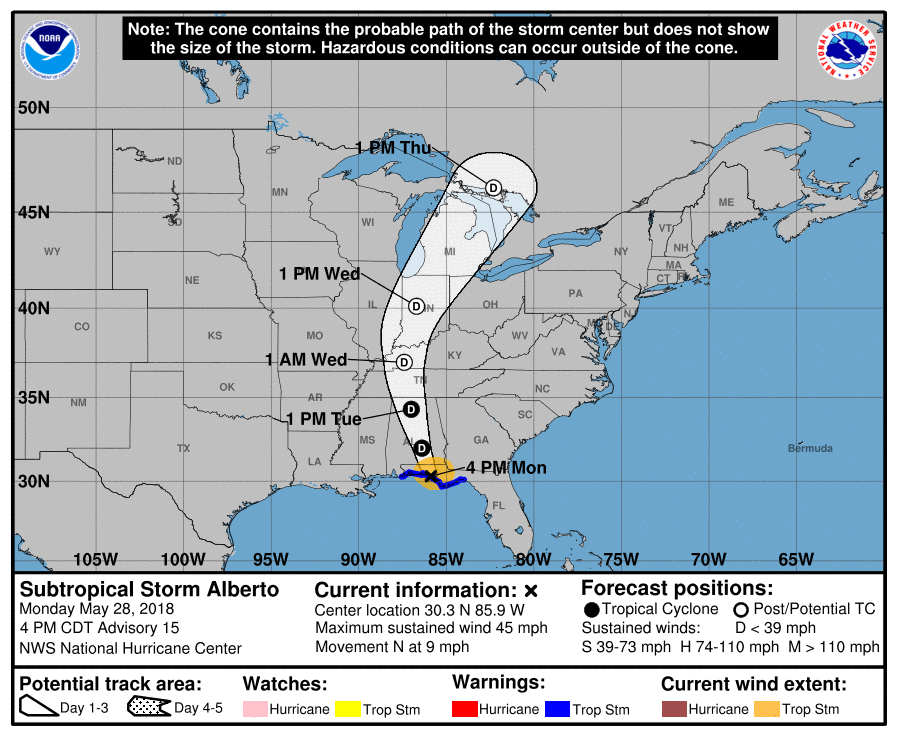
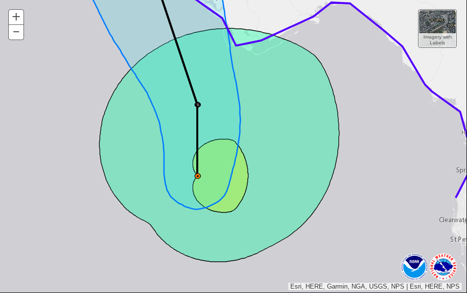
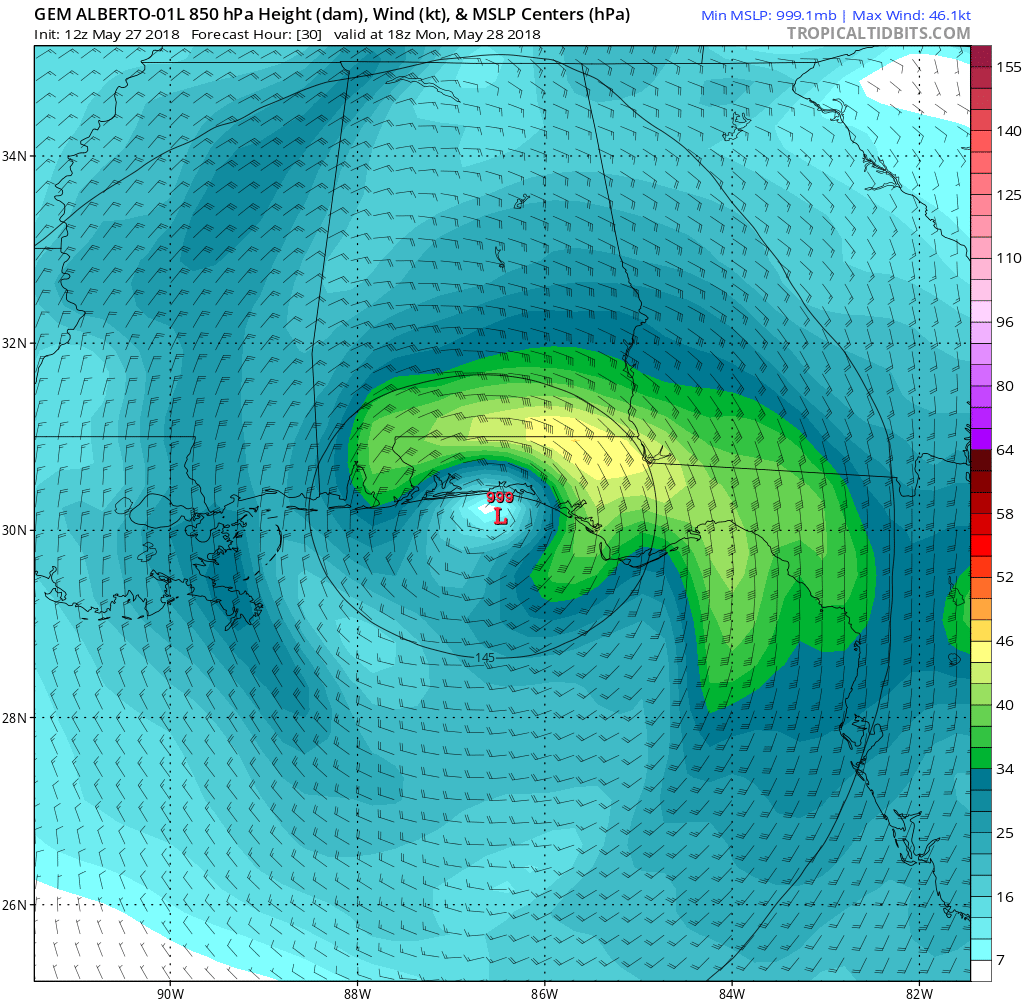
Alberto making landfall as Subtropical cyclone.
4:00 PM CDT 05/28/2018
Alberto has made landfall over Laguna beach, Florida. The track is taking it north. Winds are extending to panama city and beyond. Winds of 40 MPH was recorded.
Top: Cone
Bottom: Winds
Alberto has made landfall over Laguna beach, Florida. The track is taking it north. Winds are extending to panama city and beyond. Winds of 40 MPH was recorded.
Top: Cone
Bottom: Winds
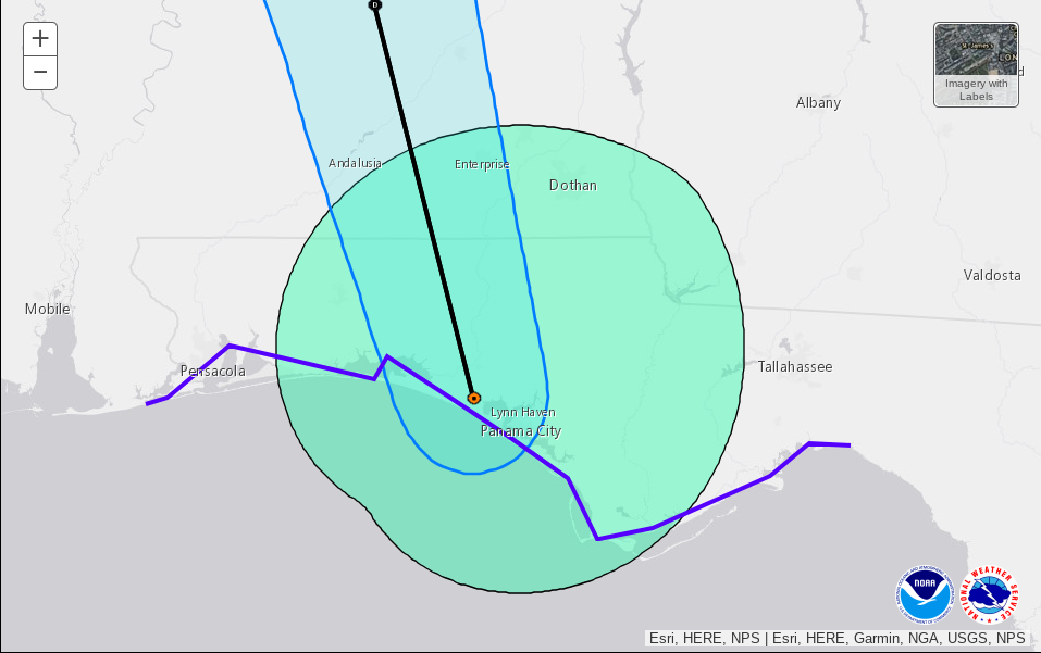
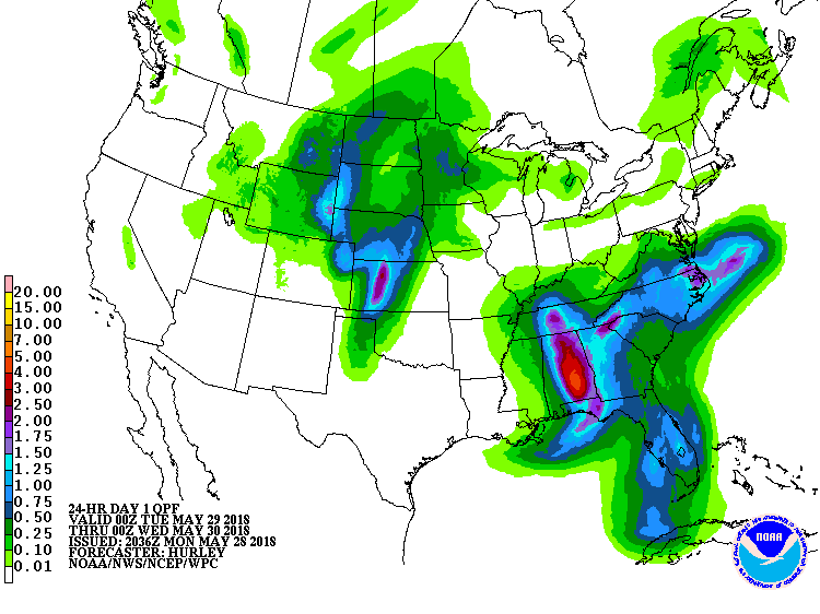
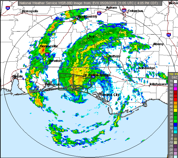
Impacts
A few areas are going to experience winds to 45 MPH. The greatest threat is Flooding, with a Flash flood warning in Okaloosa and Walton counties. Storm surge threat is low. Otherwise, no impacts are expected. This is the last post on Alberto. Will post when needed. Remember, hurricane season starts on June 1st.
Top: QPF
Bottom: Flash Flood Warnings
Top: QPF
Bottom: Flash Flood Warnings
Comments
0 comments
Update
8 PM EDT
Alberto has strengthened. Winds of 65 MPH are occurring. Tropical storm force winds have arrived at the southern tip of Florida. Will update tonight or tomorrow morning. The track has not changed yet, but will at 10 PM. MAY update, but may not.
Image: Screenshot of wind field up-close.
Alberto has strengthened. Winds of 65 MPH are occurring. Tropical storm force winds have arrived at the southern tip of Florida. Will update tonight or tomorrow morning. The track has not changed yet, but will at 10 PM. MAY update, but may not.
Image: Screenshot of wind field up-close.
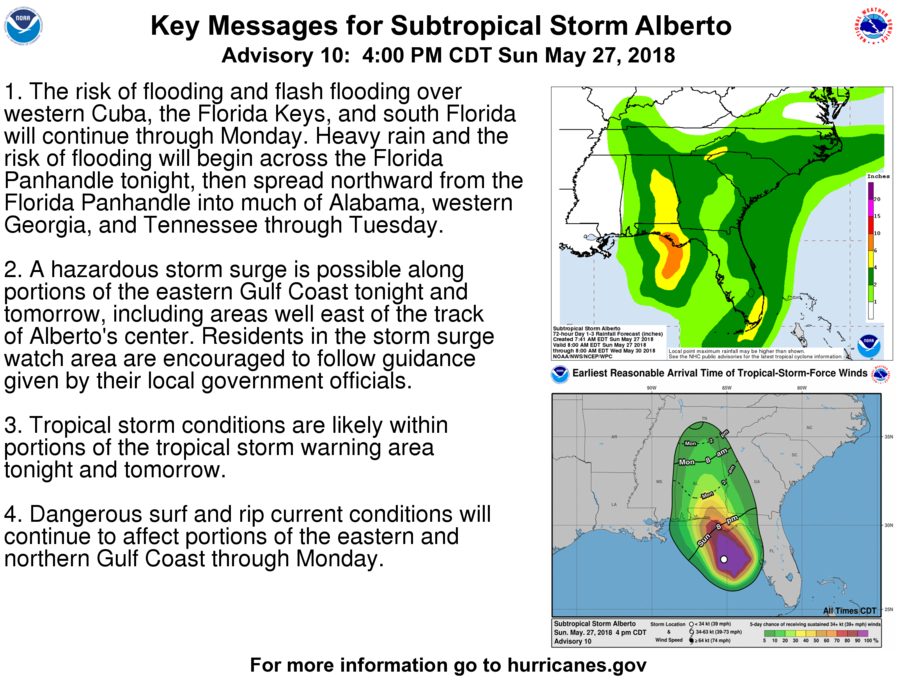
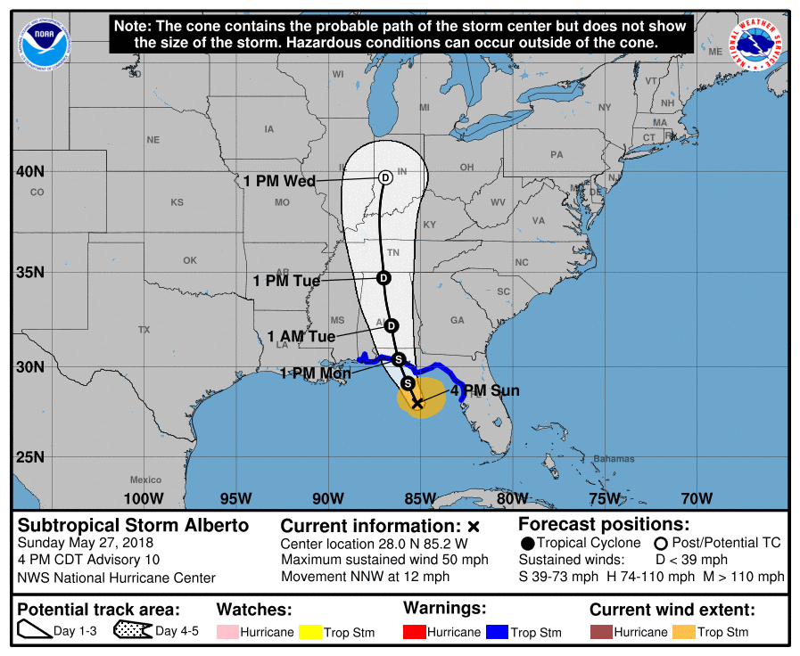
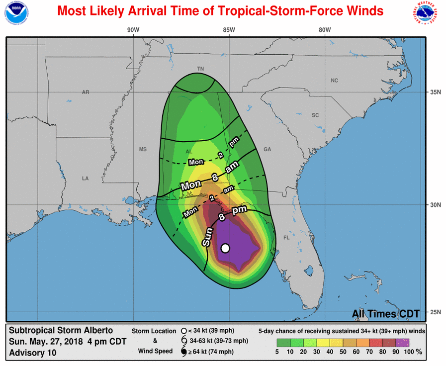
Alberto soon to make landfall; starts to move northwesterly
5:00 PM EDT 05/27/2018
The NHC has issued a new advisory. Alberto is not yet a tropical cyclone, but will soon be one. The arrival time of winds is closing in. ST Georges island is going to get winds within the next hour or so. It will spread north from there, with arrival time 8 PM to 7 AM depending on where you live.
Top: 3 day cone
Arrival time of winds (Most likely)
Impacts
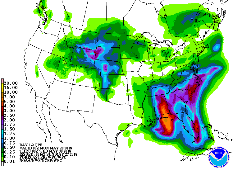
All impacts are possibly slightly less. Winds 55 MPH gusting to 65 MPH are possible. Winds will be as far west as Mobile, Alabama, and as far East as the big bend. Storm surge of 2 to 4 feet is possible. Waves 10 to 18 feet possible, with a High surf warning in the NWS Mobile, AL area. Rainfall of a foot is possible in the Florida panhandle.
Top: Rainfall total
Bottom: Computer model showing winds (courtesy tropical tidbits)
Top: Rainfall total
Bottom: Computer model showing winds (courtesy tropical tidbits)
Comments
0 comments
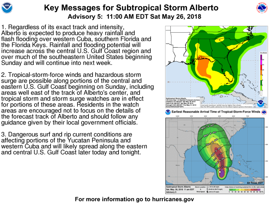
UPGRADE: Advisory 6 Issues Warnings for the coast in Florida, as well as Mobile, and Baldwin, Alabama
5:00 PM EDT 05/26/2018
The 5 PM EDT advisory was issued. These are a few pictures. Read previous post for impacts.
Go to NHC for more. Link on homepage.
Top: Key messages
Bottom: Track (3 day)
The 5 PM EDT advisory was issued. These are a few pictures. Read previous post for impacts.
Go to NHC for more. Link on homepage.
Top: Key messages
Bottom: Track (3 day)
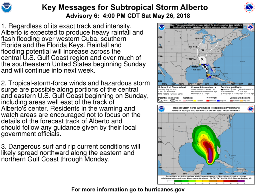
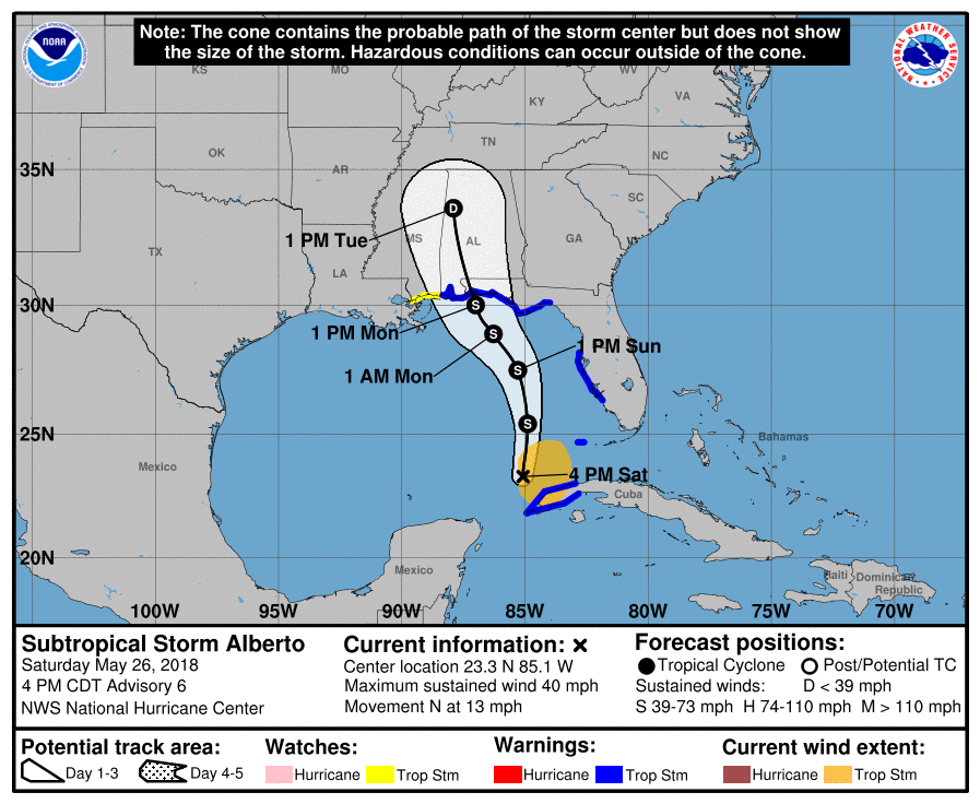
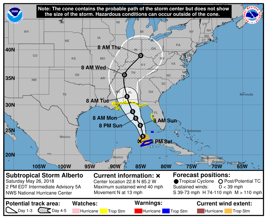
Alberto's new center formed; high surf warnings issued in prepreations
3:00 PM EDT 05/26/2018
Image: Key messages
At the 2 PM EDT advisory, Alberto has formed its new center. The storm is now moving north at 10 MPH. It will continue north, and take a turn toward the North-Northwest, becoming northwest. It will make landfall near Pensacola beach, although because of the reformation of the center, it will likely be slightly more west, near Fort Morgan, overnight Monday or early Tuesday. The winds will likely arrive in this area around 8 AM Monday, although it may arrive as early as 8 PM Sunday.
Top: 5 Day cone
Bottom: Arrival time of winds (Most likely)
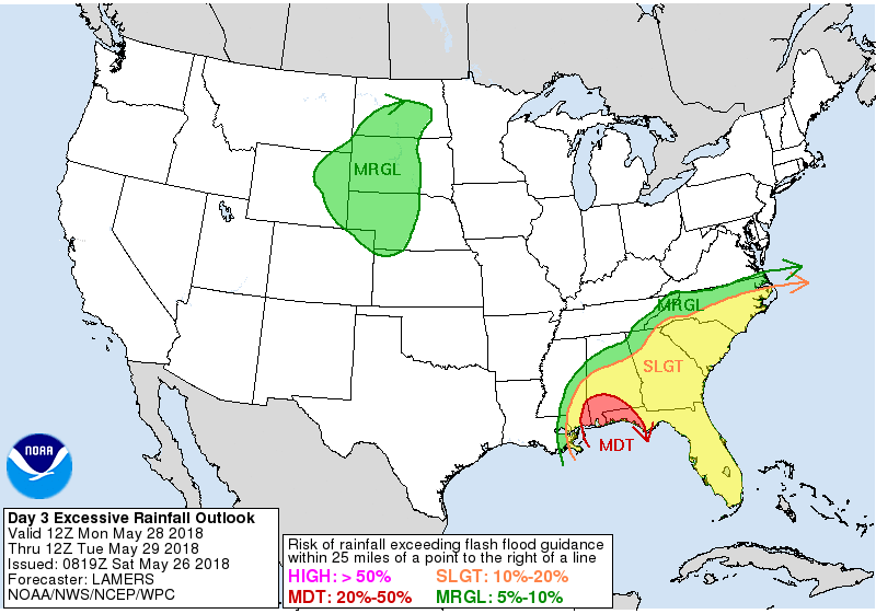
Impacts
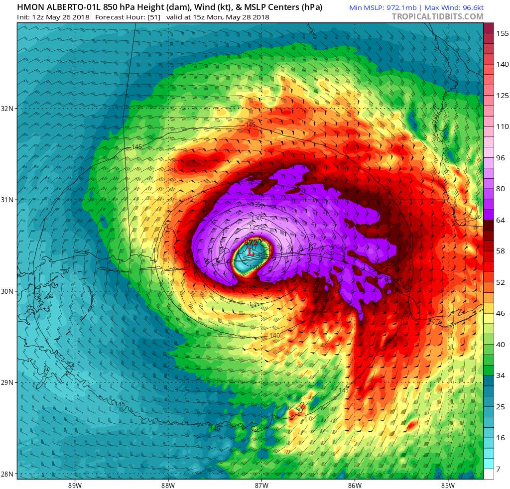
Very heavy rainfall is expected. Totals of 8 to 11 inches is possible. Some tornadoes are also a threat. High surf is the greatest threat. A high surf warning was issued earlier. Waves of 10 to 18 feet are possible. Usually, a high surf warning is issued in Hawaii. This is rare for this area, as one has not been issued since 2013 (that's how far records go back). Winds of 45 to 60 MPH gusting to 80 MPH are also possible on the coast of Alabama and Florida.
Top: Risk of flash flooding (Day 3)
Bottom: HMON model of wind speed in knots
Top: Risk of flash flooding (Day 3)
Bottom: HMON model of wind speed in knots
Comments
0 comments
Alberto Forms; Watches issued for US as this system gets closer
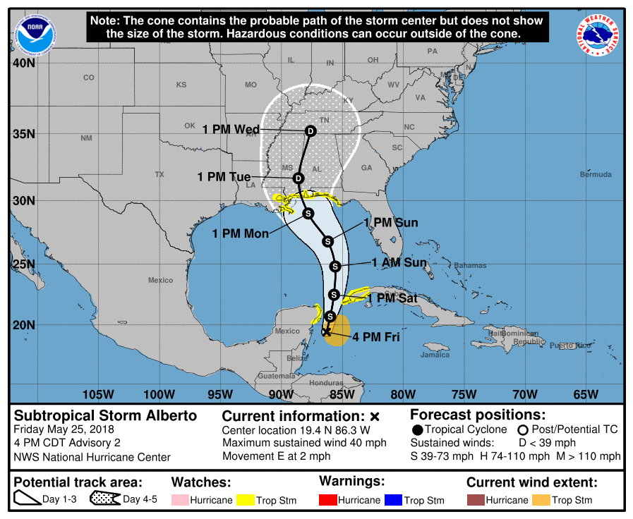
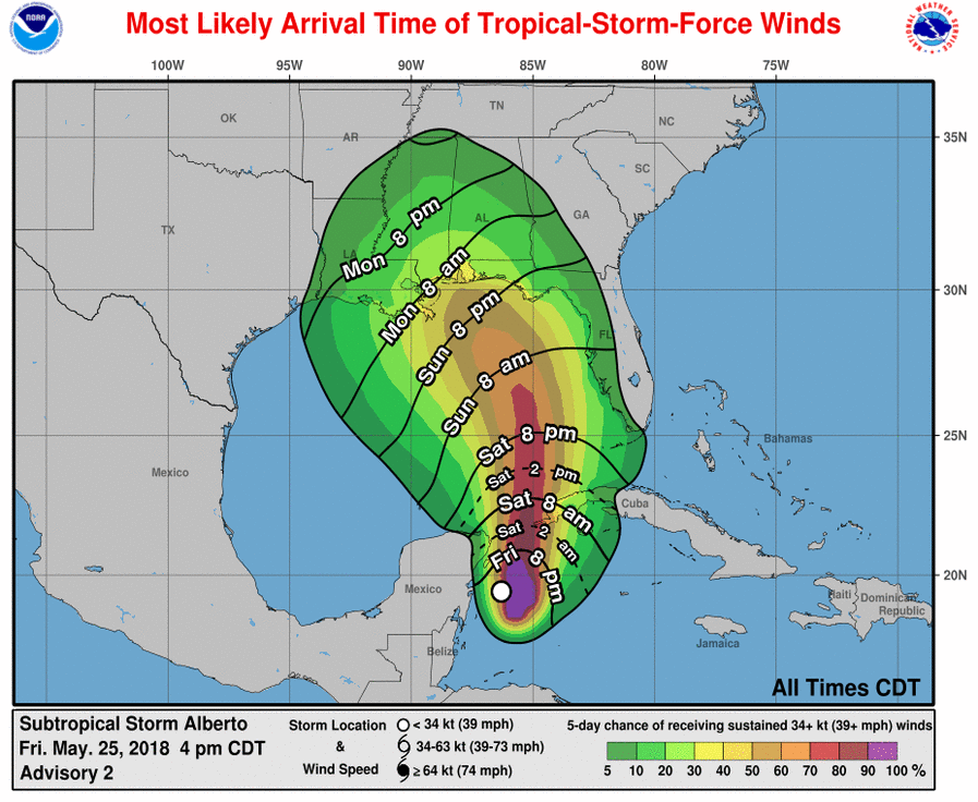
5:00 PM EDT 05/25/2018
90-L became Alberto this morning. It is a subtropical cyclone. It has winds of 40 MPH. It is located between Cuba and Belize. It is moving east at 2 MPH. This could dump 10 to 12 inches of rain. The cone brings it northward to Mobile, Alabama.
Top: 5 Day cone with track
Bottom: Arrival time of winds
Impacts
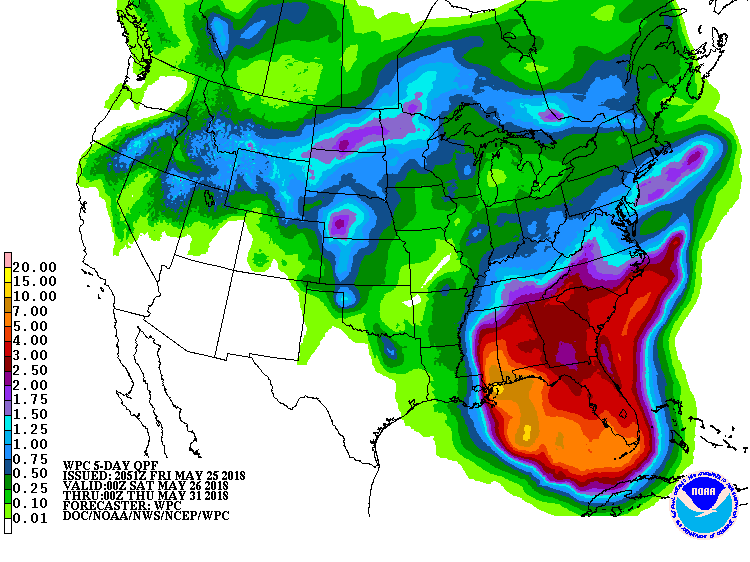
There will be several impacts. Rainfall will be the greatest, with 10 to 12 and possibly double that possible. Strong winds, mainly on the East, of up to 60 MPH, gusting to 75 MPH. Storm surge and coastal flooding is also possible. Tornadoes will be possible in the outer bands.
Top: Rainfall QPF
Bottom: Risk of flash flooding (Day 3)
Top: Rainfall QPF
Bottom: Risk of flash flooding (Day 3)
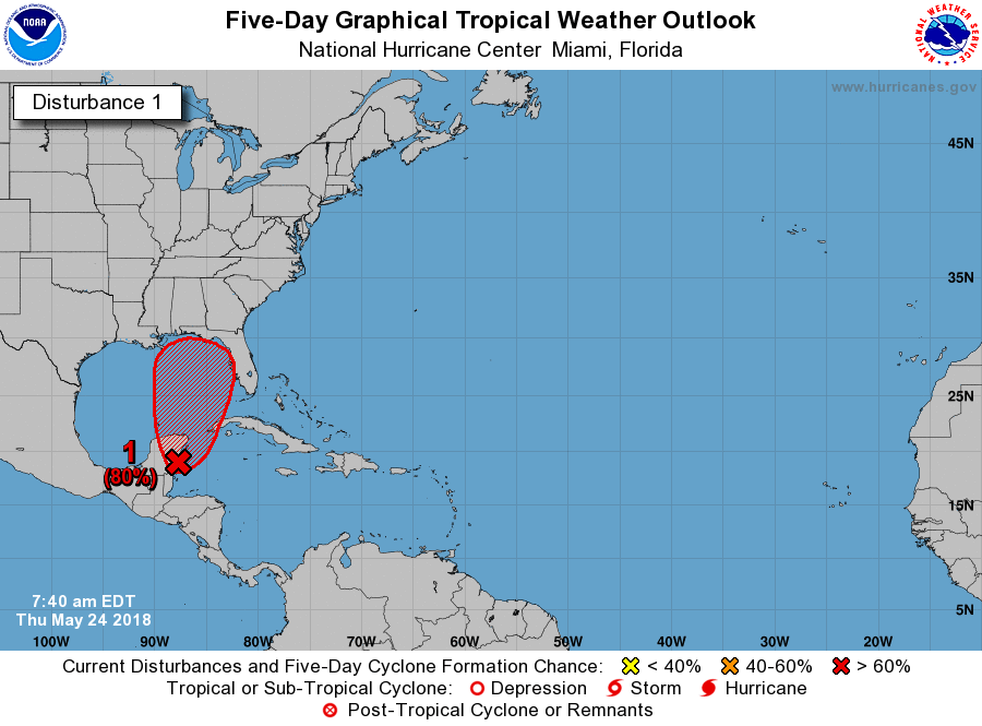
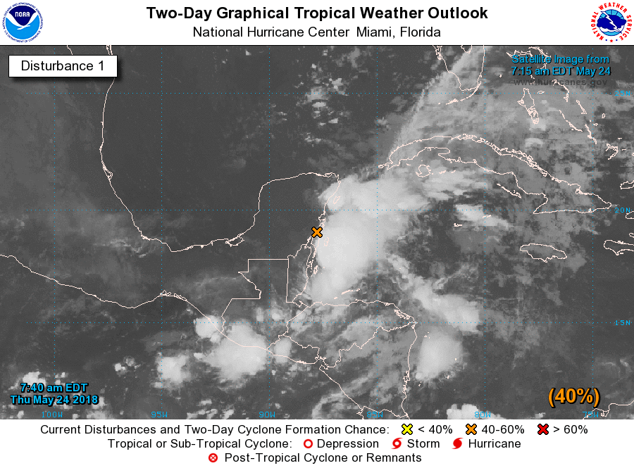
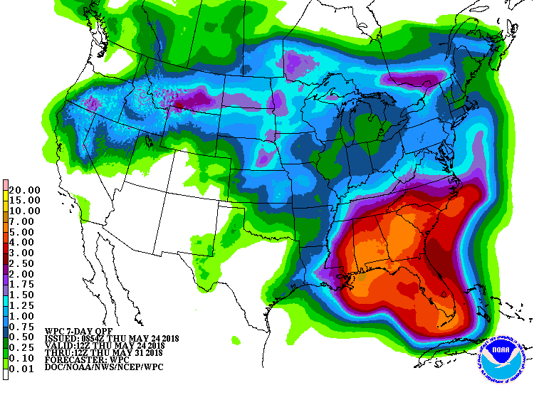
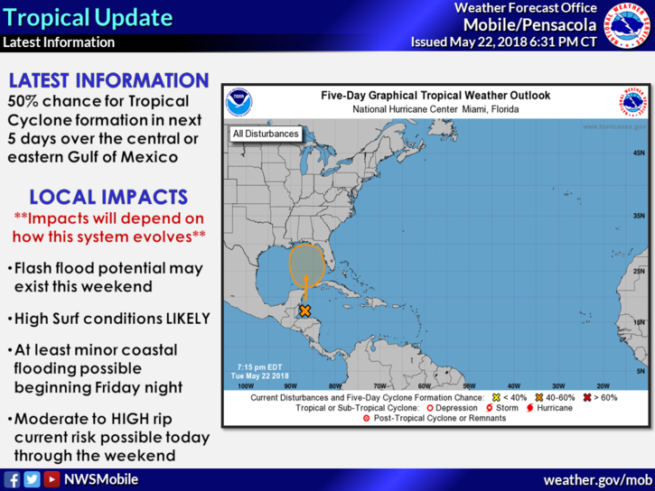
90-L will become tropical cyclone by Saturday; Possibly record-breaking rainfall
8:00 AM EDT 05/24/2018
Well, Invest 90-L will likely become a Tropical cyclone by Saturday. It is currently over the Yucatan peninsula. It will move north and will hit the gulf coast on Sunday night to Monday morning. The system, however, may dump rain until Thursday. This is the NHC text:
1. A broad, stationary surface low pressure system centered over the southeastern Yucatan Peninsula is gradually becoming better defined. Although showers and thunderstorms, along with strong gusty winds, are confined primarily to the adjacent waters of the northwestern Caribbean Sea, gradual development of this system is expected during the next couple of days as it drifts northward near the Yucatan Peninsula. Environmental conditions are forecast to become more conducive for development through early next week, and a subtropical or tropical depression is likely to form by late Saturday over the southeastern Gulf of Mexico. Regardless of development, locally heavy rainfall is forecast across western Cuba and over much of Florida and the northern Gulf Coast into early next week. In addition, the threat of rip currents will steadily increase along the Gulf coast from Florida westward to Louisiana over Memorial Day weekend. For more information on these threats, please see products issued by your local weather office. The next Special Tropical Weather Outlook on this system will be issued by 200 PM EDT this afternoon.
* Formation chance through 48 hours...medium...40 percent.
* Formation chance through 5 days...high...80 percent.
Go to Impacts section for more.
Top: 5 day
Bottom: 2 day with clouds
Potential track
This system is slowly moving northward. It will start to move on Saturday, and make landfall late Sunday or early Monday. It will likely then slow down, and dump rain. It is still a little uncertain, but it will likely make landfall between Louisiana and Florida.
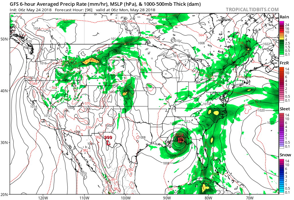
Image courtesy: Tropical Tidbits
This image shows the GFS model making landfall at 2 AM EDT near Pensacola, Florida.
This image shows the GFS model making landfall at 2 AM EDT near Pensacola, Florida.
Impacts
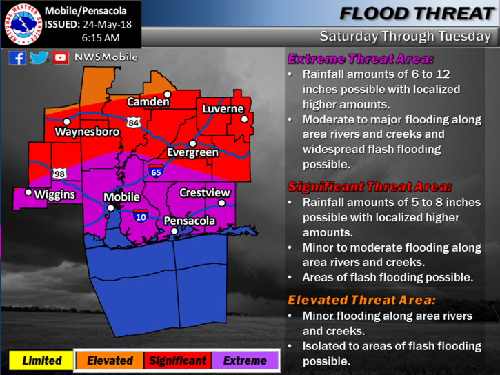
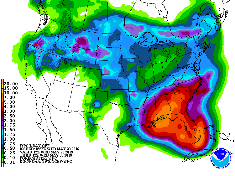
The tropical system will almost certainly produce strong rip currents. Coastal flooding is also a hazard. Winds of 25 to 35 MPH are possible. If it is a tropical storm, it will likely only get up to 40-45 MPH. The severest threat is heavy rain. There is a chance of 10 to 12 inches of rain in NW Florida panhandle, and Southern Alabama. The NWS Mobile Alabama has an extreme risk of flooding, and a hydrologic outlook. Go to www.weather.gov/mob for more. It is still a little to early to determine all impacts, but stay tuned. Will write a new article as soon as this system forms.
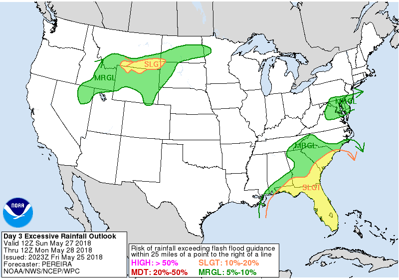
Top: QPF
Bottom: NWS Mobile, AL rainfall risk "Extreme"
Top: QPF
Bottom: NWS Mobile, AL rainfall risk "Extreme"
Comments
0 comments
Post a comment
Fill this out, and I will post the comment. NOTE: NAME WILL BE RELEASED, BUT EMAIL WILL NOT.
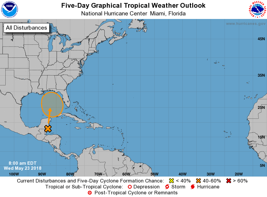
First invest of 2018, 90-L, May become first tropical cyclone
|
8:00 AM EDT 05/23/2018
This morning, the NHC has given the system a medium to high chance of development. This is a 60% in 5 days. However, due to strong wind shear, this has a 0% chance of development over the next 48 hours. If it forms, it would take the name Alberto. It would be a pre-season storm. This is moving directly north, and could hit anywhere from Texas to East coast of Florida. Go to impacts section for more on impacts. The "X"is where the centre is, while the arrow is where it will go. The circled area is where it will develop. This is the Text of the NHC product: ZCZC MIATWOAT ALL TTAA00 KNHC DDHHMM CCA Special Tropical Weather Outlook...Corrected NWS National Hurricane Center Miami FL 800 AM EDT Wed May 23 2018 Corrected header For the North Atlantic...Caribbean Sea and the Gulf of Mexico: 1. A broad surface low centered near the coast of northeastern Belize continues to produce a large area of cloudiness and showers extending from the northwestern Caribbean Sea across Cuba and into the Florida Straits. Little development is expected during the next couple of days due to strong upper-level winds and proximity to the Yucatan Peninsula. However, environmental conditions are then forecast to become more conducive for development, and a subtropical or tropical depression could form this weekend over the eastern or central Gulf of Mexico. Regardless of development, locally heavy rainfall is possible across western Cuba and the Cayman Islands during the next few days, and over much of Florida and the northern Gulf Coast during the weekend. For more information on the heavy rain threat, please see products issued by your local weather office. The next Special Tropical Weather Outlook on this system will be issued by 800 PM EDT. * Formation chance through 48 hours...low...near 0 percent. * Formation chance through 5 days...medium...60 percent. Forecaster Blake
Top: 5 day
Bottom: 2 day with clouds
Impacts
These impacts are dependent on what forms. Most likely, heavy rain will occur. There will be high surf, High risk of rip currents, and minor coastal flooding. If it develops, tornadoes and wind 35 to 45 MPH are possible. It is still too early to discuss full impacts, so stay tuned. Look for an update in a day or two.
Top: QPF
Bottom: NWS Mobile AL possible threats (As of Last night)
Top: QPF
Bottom: NWS Mobile AL possible threats (As of Last night)
Retired Names Unveiled
9:30 AM EDT 04/14/2018
The World meteorological organization has retired 4 names, which will be added to the list. They retire names to prevent sadness or to prevent inappropriate use, such as Sandy, or Rita, or Alison. Here are the names and what they did.
Harvey: Harvey was the worst and costliest tropical cyclone of all time. It flooded Texas, Especially Houston, but effects were felt as far East as Pensacola, Florida. Harvey will be replaced with Harold.
Irma: Irma Was the strongest tropical cyclone in the Atlantic. The strongest all time was Patricia, in the Pacific in 2015. Irma devastated many Caribbean islands. Then it made landfall near Marco Island in Florida. It devastated south Florida. Irma will be replaced with Idalia.
Maria: Maria strengthened unbelievably fast. It went and caused damage to islands, and devastated Puerto Rico. Then it caused little damage to North Carolina. Maria will be replaced with Margot.
Nate: Nate became the fastest storm on record. It moved through the Gulf. But first, it hit Honduras, and Nicaragua. It killed several people. Then, it hit Louisiana and Mississippi, with tropical storm force winds as far east as Pensacola, FL. Nate will be replaced with Nigel.
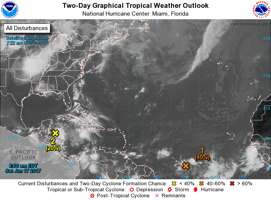
All systems will likely form
10:00 AM EDT 6/17/17
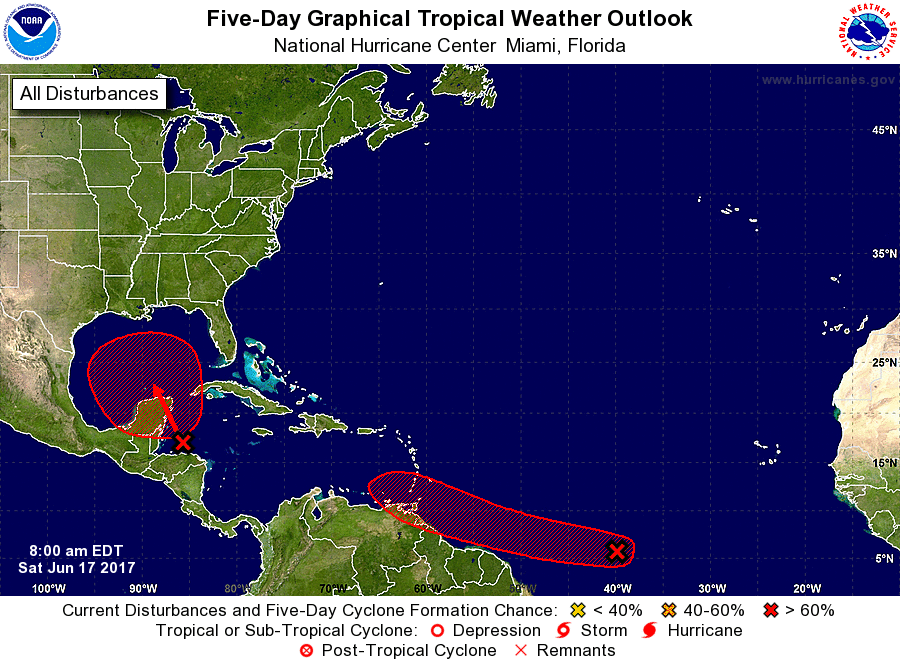
The NHC gives all systems a high chance of development for all systems within 5 days. The system in the atlantic has become more organized over 24 hours. This system has a 40% chance of development over 48 hrs, and a 70% chance of development over 5 days. That is the same chance for the other one in the gulf, but it has a 20% chance in 48hrs. This system in the gulf will hit Texas and Louisiana, but it still may change direction, as there are some systems that may shift its path. The red arrow shows which way is likely; That is To Texas/ Louisiana. The one in the Atlantic will go above south America, but it will probably die out over the Caribbean due to strong wind shear. There will be flooding, wind, and rip currents. We still can't predict 100% what will ultimately happen to the systems, and where it will make final landfall.
Top: 5 day
Bottom: 2 day with clouds
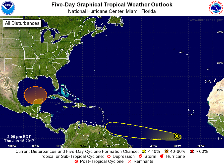
Gulf System organizes more, Atlantic storm may not get strong
2:00 PM EDT 6/15/17
The NHC changed the forecast a lot. The system in the gulf now has a 50% chance of formation within 5 days, with a 0% with in 48 hours. The little X will not show up on 48 hr forecast, as its a 0%. The reason why its that low is because it will hit the Yucatan Peninsula. The models show that it will go to Mexico, and not affect the USA. Or, an other scenario says it will go to Louisiana as a Tropical Depression, and cause Flooding in Louisiana, Mississippi Alabama, and the Northwest Florida Panhandle. However with the way its moving, it will probably go to Texas, and Louisiana. The other wave has a 10% in 48hrs and 20% in 5 days. It will probably not form now, as it is too close to the equator. If it does form, it will cause flooding over South America. It will probably not make it across the Caribbean, as there is too much wind shear. It may not even make it on to a Tropical Cyclone. That will not stop it from flooding.
Top: 5 day
Bottom: 2 Day with clouds
Tropical Cyclones may Form
2:00 PM EDT 6/14/17
Today the National Hurricane Center (NHC) marked an other area that may become a tropical cyclone. There was another one East of the Yucatan Peninsula. It had a 0% chance of formation within 48 hours, and a 20% chance of formation within 5 days. This will probably become more organized over the Gulf of Mexico with in 7 days. When it makes landfall, it will probably hit Texas/Louisiana in about 10 days, as it moves northwestward. It may become a tropical cyclone in that time, because waters are over 80 Degrees Fahrenheit which is enough to form a tropical cyclone. The new tropical disturbance is several hundred miles south of the Cabo Verde. It is a strong tropical wave that came off the cost of Africa. It formed with dry air, that became a tropical wave, then At 2 am EDT, the NHC marked that it may develop. It has a 10% chance of development within 48 hours, and a 20% chance within 5 Days. This system is moving west north westward. It will affect south America in 3-4 days, as well as the Lesser Antilles in 6 days. After that, it will either go north across Hati ant on the Atlantic coast, or in the Gulf of Mexico and on the Gulf Cost.
Today the National Hurricane Center (NHC) marked an other area that may become a tropical cyclone. There was another one East of the Yucatan Peninsula. It had a 0% chance of formation within 48 hours, and a 20% chance of formation within 5 days. This will probably become more organized over the Gulf of Mexico with in 7 days. When it makes landfall, it will probably hit Texas/Louisiana in about 10 days, as it moves northwestward. It may become a tropical cyclone in that time, because waters are over 80 Degrees Fahrenheit which is enough to form a tropical cyclone. The new tropical disturbance is several hundred miles south of the Cabo Verde. It is a strong tropical wave that came off the cost of Africa. It formed with dry air, that became a tropical wave, then At 2 am EDT, the NHC marked that it may develop. It has a 10% chance of development within 48 hours, and a 20% chance within 5 Days. This system is moving west north westward. It will affect south America in 3-4 days, as well as the Lesser Antilles in 6 days. After that, it will either go north across Hati ant on the Atlantic coast, or in the Gulf of Mexico and on the Gulf Cost.
Top: 5 day outlook
Bottom: 2 day. one near Mexico very disorganized.
Bottom: 2 day. one near Mexico very disorganized.
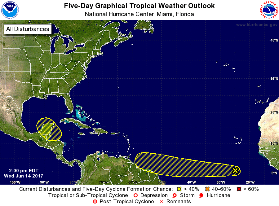
Impacts
The disturbance near Mexico will cause flooding over the Yucatan Peninsula. When it makes landfall there will be flooding, very minor, or no storm surge, and Minor, to Moderate wind damage. Also, major rip currents will occur. The wave off of Africa will cause flooding in South America, and the caribbean islands. When it becomes a tropical cyclone, if it does, there will be flooding Minor, to Moderate wind damage, and rip currents. Stay Tuned for updates every 2-3 days.
